![](/images/other/stat-length.png)
![Tocht Te voet La Genevraye - Du canal du Loing au berges du Lunain - Photo](https://media.geolcdn.com/t/1900/400/f5bc045f-e010-4cc1-a4ef-a06cb0f8d565.jpeg&format=pjpeg&maxdim=2)
Du canal du Loing au berges du Lunain
SityTrail - itinéraires balisés pédestres
Tous les sentiers balisés d’Europe GUIDE+
![Lengte](/images/other/stat-length.png)
Lengte
5,1 km
![Max. hoogte](https://static1.geolcdn.com/siteimages/upload/files/1508320355ic_sort_altitude_max_24dp.png)
Max. hoogte
63 m
![Positief hoogteverschil](https://static1.geolcdn.com/siteimages/upload/files/1508320355ic_sort_den_pos_24dp.png)
Positief hoogteverschil
26 m
![Km-Effort](/images/other/stat-length.png)
Km-Effort
5,5 km
![Min. hoogte](https://static1.geolcdn.com/siteimages/upload/files/1508320355ic_sort_altitude_min_24dp.png)
Min. hoogte
51 m
![Negatief hoogteverschil](https://static1.geolcdn.com/siteimages/upload/files/1508320355ic_sort_den_neg_24dp.png)
Negatief hoogteverschil
33 m
![Boucle](https://static1.geolcdn.com/siteimages/upload/files/16400158638029165_repeat_loop_refresh_sync_direction_icon.png)
Boucle
Neen
Markering
Datum van aanmaak :
2022-02-15 01:30:11.682
Laatste wijziging :
2022-03-02 10:04:57.826
![Te voet](https://static1.geolcdn.com/sitytour/trail-icons/100.png)
1h15
Moeilijkheid : Gemakkelijk
![Scan deze QR-code om de tocht te openen in de SityTrail-applicatie](https://capi.geolives.com/qq0zvz2zws4bq2lad0pu/sitytour/trails/3113308/qr.png?size=200)
Gratisgps-wandelapplicatie
Over ons
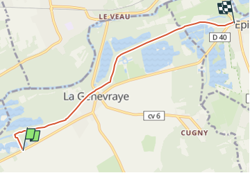
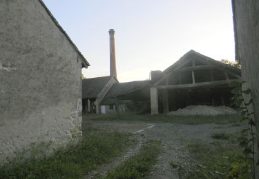
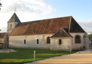
Tocht Te voet van 5,1 km beschikbaar op Île-de-France, Seine-et-Marne, La Genevraye. Deze tocht wordt voorgesteld door SityTrail - itinéraires balisés pédestres.
Beschrijving
Trail created by Moret Seine & Loing.
Plaatsbepaling
Land:
France
Regio :
Île-de-France
Departement/Provincie :
Seine-et-Marne
Gemeente :
La Genevraye
Locatie:
Unknown
Vertrek:(Dec)
Vertrek:(UTM)
479905 ; 5351140 (31U) N.
Opmerkingen
Wandeltochten in de omgeving
![Tocht Stappen Fontainebleau - GLM-150311 - PVerte-Fourceau-Béatrix - Photo](https://media.geolcdn.com/t/375/260/ext.jpg?maxdim=2&url=https%3A%2F%2Fservices.sitytrail.com%2FGeolivesWS%2FDownloadMedia.ashx%3FTrailID%3D394980%26Media%3D3b15c306-0eca-40de-a57d-3cf59ddfeba2.jpg)
![Stappen Stappen](https://static1.geolcdn.com/sitytour/trail-icons/101.png)
GLM-150311 - PVerte-Fourceau-Béatrix
Stappen
Medium
(1)
Fontainebleau,
Île-de-France,
Seine-et-Marne,
France
![](/images/other/stat-length.png)
16,5 km | 20 km-effort
6h 0min
![](https://static1.geolcdn.com/siteimages/upload/files/16400158638029165_repeat_loop_refresh_sync_direction_icon.png)
Ja
![Tocht Stappen Bourron-Marlotte - Boucle Bourron Marlotte ( reco Didier) - Photo](https://media.geolcdn.com/t/375/260/ext.jpg?maxdim=2&url=https%3A%2F%2Fstatic1.geolcdn.com%2Fsiteimages%2Fupload%2Ffiles%2F1553511878bg_sport_marche.png)
![Stappen Stappen](https://static1.geolcdn.com/sitytour/trail-icons/101.png)
Boucle Bourron Marlotte ( reco Didier)
Stappen
Gemakkelijk
(1)
Bourron-Marlotte,
Île-de-France,
Seine-et-Marne,
France
![](/images/other/stat-length.png)
28 km | 32 km-effort
5h 35min
![](https://static1.geolcdn.com/siteimages/upload/files/16400158638029165_repeat_loop_refresh_sync_direction_icon.png)
Ja
![Tocht Stappen Fontainebleau - viennes carosses - Photo](https://media.geolcdn.com/t/375/260/9b54e644-4214-4411-b7b4-ea5a49e11005.jpg&format=jpg&maxdim=2)
![Stappen Stappen](https://static1.geolcdn.com/sitytour/trail-icons/101.png)
viennes carosses
Stappen
Heel gemakkelijk
(2)
Fontainebleau,
Île-de-France,
Seine-et-Marne,
France
![](/images/other/stat-length.png)
10,8 km | 14 km-effort
2h 50min
![](https://static1.geolcdn.com/siteimages/upload/files/16400158638029165_repeat_loop_refresh_sync_direction_icon.png)
Ja
![Tocht Te voet Saint-Pierre-lès-Nemours - Le Mont Blanc de la Commanderie - Photo](https://media.geolcdn.com/t/375/260/44b5b534-5554-427f-a1ac-872604acda7f.jpg&format=jpg&maxdim=2)
![Te voet Te voet](https://static1.geolcdn.com/sitytour/trail-icons/100.png)
Le Mont Blanc de la Commanderie
Te voet
Medium
Saint-Pierre-lès-Nemours,
Île-de-France,
Seine-et-Marne,
France
![](/images/other/stat-length.png)
26 km | 30 km-effort
6h 50min
![](https://static1.geolcdn.com/siteimages/upload/files/16400158638029165_repeat_loop_refresh_sync_direction_icon.png)
Neen
![Tocht Te voet Moret-Loing-et-Orvanne - La basse vallée du Lunain version 30 km - Photo](https://media.geolcdn.com/t/375/260/7e9d55c6-78ba-44d4-861c-7056fde52aaa.jpg&format=jpg&maxdim=2)
![Te voet Te voet](https://static1.geolcdn.com/sitytour/trail-icons/100.png)
La basse vallée du Lunain version 30 km
Te voet
Moeilijk
Moret-Loing-et-Orvanne,
Île-de-France,
Seine-et-Marne,
France
![](/images/other/stat-length.png)
30 km | 34 km-effort
7h 39min
![](https://static1.geolcdn.com/siteimages/upload/files/16400158638029165_repeat_loop_refresh_sync_direction_icon.png)
Ja
![Tocht Te voet Bourron-Marlotte - Boucle 30 km Bourron Marlotte - Montigny/ Loing / Grez - Photo](https://media.geolcdn.com/t/375/260/04503fe2-d147-4df8-acdc-18641722dd77.jpg&format=jpg&maxdim=2)
![Te voet Te voet](https://static1.geolcdn.com/sitytour/trail-icons/100.png)
Boucle 30 km Bourron Marlotte - Montigny/ Loing / Grez
Te voet
Moeilijk
Bourron-Marlotte,
Île-de-France,
Seine-et-Marne,
France
![](/images/other/stat-length.png)
28 km | 32 km-effort
7h 14min
![](https://static1.geolcdn.com/siteimages/upload/files/16400158638029165_repeat_loop_refresh_sync_direction_icon.png)
Ja
![Tocht Te voet Villemer - Basse vallée du Lunain - Photo](https://media.geolcdn.com/t/375/260/0470e7e1-a330-4ce3-ab0c-a434b6e7cece.jpeg&format=jpg&maxdim=2)
![Te voet Te voet](https://static1.geolcdn.com/sitytour/trail-icons/100.png)
Basse vallée du Lunain
Te voet
Gemakkelijk
Villemer,
Île-de-France,
Seine-et-Marne,
France
![](/images/other/stat-length.png)
17,3 km | 20 km-effort
4h 32min
![](https://static1.geolcdn.com/siteimages/upload/files/16400158638029165_repeat_loop_refresh_sync_direction_icon.png)
Ja
![Tocht Te voet Montigny-sur-Loing - De Kosciusko à Croc Marin - Photo](https://media.geolcdn.com/t/375/260/f5bc045f-e010-4cc1-a4ef-a06cb0f8d565.jpeg&format=jpg&maxdim=2)
![Te voet Te voet](https://static1.geolcdn.com/sitytour/trail-icons/100.png)
De Kosciusko à Croc Marin
Te voet
Medium
Montigny-sur-Loing,
Île-de-France,
Seine-et-Marne,
France
![](/images/other/stat-length.png)
17,5 km | 21 km-effort
4h 42min
![](https://static1.geolcdn.com/siteimages/upload/files/16400158638029165_repeat_loop_refresh_sync_direction_icon.png)
Ja
![Tocht Stappen Moret-Loing-et-Orvanne - RSL 011 - Photo](https://media.geolcdn.com/t/375/260/ext.jpg?maxdim=2&url=https%3A%2F%2Fstatic1.geolcdn.com%2Fsiteimages%2Fupload%2Ffiles%2F1553511878bg_sport_marche.png)
![Stappen Stappen](https://static1.geolcdn.com/sitytour/trail-icons/101.png)
RSL 011
Stappen
Heel gemakkelijk
(1)
Moret-Loing-et-Orvanne,
Île-de-France,
Seine-et-Marne,
France
![](/images/other/stat-length.png)
17,7 km | 20 km-effort
5h 0min
![](https://static1.geolcdn.com/siteimages/upload/files/16400158638029165_repeat_loop_refresh_sync_direction_icon.png)
Ja